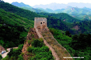
I've been looking at the rally route on Google Earth. The first stop, Datong, is north and east from Beijing over the Yan Shan mountains which are crossed by the Great Wall (see photo). These mountains only rise to about 1,000m but go on for ever. As the crow flies Day 1 should be 342 Km but our route is 388 Km, so perhaps we are being routed through the Wu Ling national park.
Day 2, from Datong to Erenhot is going to be a beast. This is a 573 Km stretch through the edges of the Gobi desert, flat and hot. The direct route is 459 Km so the organisers clearly have bad stuff in mind for us.
Day 3 from Erenhot to Undershireet is so difficult that Google Maps can't even give me a normal route or approximate distance, but it is 400 Km for us.
Day 4 from Undershireet to Ulaan Baatar should be an easy 218 Km by direct road but we are taking 360 Km. Another tricky day I suspect.
Day 5 is a rest day in Ulaan Bataaar and then Day 6 from Ulaan Bataar to Bulgan is a surprise as the direct route is 470 Km but our route is only 343 Km. This probably means we are going over the top of the Yablonoviy mountain range and shortcutting the journey.
Day 7 and we are into the Khangai mountains taking 370 Km to go from Bulgan to Murun, a journey that should be only 278 Km.
Day 8 from Murun to Chajargas Lake is another mountain section taking only 390 Km instead of the Google maps route of 602Km
Days 9 and 10, from Charjargas Lake to Olgiy and then Altai Republic are both mystery days for Google Earth which can't tell me how long they should be but both are 350 Km and go over the Sayan mountains.
It seems to me that Day 1 could be rather lovely but that Days 2,3,4,6,7,8,9 and maybe 10 are pretty brutal.

you're a bit wrong, you do not go to Sayan mountains, these mountains are located elsewhere. you can see the ridge Saylyugem, as well as South and North-Chui Chui ranges. at the foot of the North -Chuyskogo you will find a special section
ReplyDelete